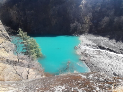
Dehradun, Feb 24 : SDRF personnel aided by the villagers have managed to widen the discharge area of a Rishiganga lake in Uttarakhand, bringing down its water level by one foot, top police officers said on Wednesday.
For the past few days, villagers have joined hands with the State Disaster Response Fund (SDRF) personnel in uprooting some trees and widening the lake’s discharge area to release more water.
By doing this, the discharge area has been widened by 20 to 50 feet which in turn brought down the water level of the lake by more than one foot, they said.
The SDRF personnel are on alert in Chamoli district after the lake was formed at the catchment area of the turbulent Rishiganga river which had caused the February 7 deluge, wreaking havoc in the district.
The lake has been formed at a height of 14,000 feet.
SDRF personnel have also been deployed at Pang and other areas along the Rishiganga lake to closely monitor the flow of water, SDRF Commandant Navneet Bhullar said.
In addition to this, alert sensors and a quick deployable antenna (QDA) have also been set up at the lake side.Through the QDA, the SDRF has established video communication with the lake area from Dehradun.
Amid growing fears, the Uttarakhand government had earlier sounded alert after satellite images found the formation of the lake in the catchment area of Rishiganga river following the February 7 deluge which had destroyed the 13.2 Mw Rishiganga hydel project completely besides damaging NTPC’s 520 Mw Tapovan-Vishnugaad hydel project to a big extent.
The lake is approximately 750-800m long and has a depth of 7-8m.
After the considerable continuous discharge from the lake, officials said there is no danger from it as of now.
The government has also sent scientists of the Wadia Institute of Himalayan Geology, the Geological Survey of India and the DRDO to the lake to prepare a detailed report.
Over 205 persons went missing after the February 7 deluge


